The Spiritual and Cultural Values of Martakert Province, Artsakh
Primary tabs
Introduction
The aim of this research-based work is to present the historical and architectural monuments of the Martakert Province of Artsakh: monasteries, fortresses, castles, etc.. The work may interest both those who are interested in the history and culture of Artsakh, as well as guests who visit Artsakh.
I was born in Martakert and I have always been interested in the history and culture of the province. I have also visited our historical places and I will try to present them in this article.
First, a little bit about Martakert.
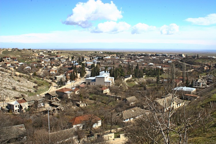
Martakert Province is located in the north of Artsakh. It occupies the area located to the north of the Khachen and Kolatak river basins. It borders Shahumyan Province in the north, Karvachar Province in the west, Askeran and Kashatagh Provinces in the south, and Azerbaijan in the east.
The total area of the province is 1795 square kilometers. To the north of the regional center Martakert, on the Tartar River, there are the Sarsang Reservoir and a Hydro Power Plant, which have strategic importance for the republic.
The name Martakert is the phonetic variant of "Maturakert"- (chapel maker in Armenian. There are also other variants like "Mardakert" - made by man (man-մարդ), or "Martakert" - created during battles (battle-մարտ). On July 7, 1992, Azerbaijan occupied Martakert and named it "Aghdere". The Azerbaijani name of the city means "white valley". There are many limestone mines in Martakert, and limestone was used as a building material.
Azerbaijanis controlled Martakert for almost a year. The region with around 50,000 inhabitants was left almost completely without Armenians. On June 27, 1993, the city was liberated. In 1994 an armistice was signed and several villages of Martakert remained under the control of Azerbaijan.
Martakert has been mentioned as a village at least since the 19th century, when the St. John the Baptist church was built here. At that time, its administrative location was in the Jevanshir canton of the Elizavetpol governorate. In 1923, when the Nagorno-Karabakh Autonomous Region was formed, the village was the largest in the north, so it became the center of the region. It received the status of a city-type settlement in 1960, after Madaghiz (1943). During the years of Artsakh's independence, the settlement received the title of a town.
Martakert is famous for its historical and architectural monuments, such as Gandzasar (13th century), Yerits Mankants Monastery, Hakobavank, Yeghishe Apostol Monastery, The mansion of the Melik-Beglaryans, Jraberd, Kachaghakaberd, Khokhanaberd fortresses, etc.
Martakert takes the first place among the provinces of Artsakh in terms of the number of its ancient monuments. Unfortunately, many monasteries have not been fully explored and there is very little information.
Gandzasar
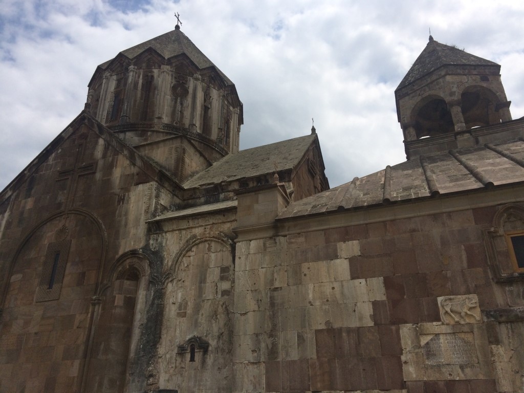
Gandzasar is one of the monastic complexes of the 10th-13th centuries, located near the village of Vank in Martakert province, formerly in Mets Arank canton of Artsakh governorate.
The Gandzasar Monastic Complex got its name from the name of the hill in front of Vank village, at the bottom of which there are mines of silver and other metals. The amazing Gandzasar monastery was the primacy and family mausoleum of Khachen princes. Thanks to the care of the princes of the Hasan-Jalalyan dynasty, Gandzasar has kept its role as a religious center. The monastery had a rich repository of manuscripts, a school, where valuable manuscripts were created and also many religious figures got their education and contributed to the development of the intellectual and cultural life of Khachen and the surrounding provinces.
The construction of the main church of the monastery, Saint John the Baptist, began in 1216. and ended in 1238. The head of St. John the Baptist is buried in the altar of the church.
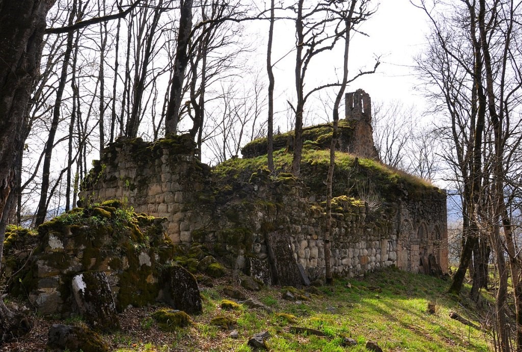
Yerits Mankants Monastery
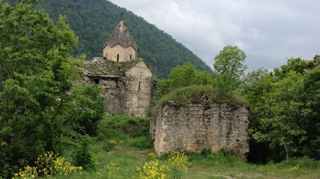
Yerits Mankants Monastery is a brilliant example of medieval Armenian Church architecture. It was built in 1691 and is located 18 km southwest of the Tonashen village, Martakert, 7 km away from the historical Jraberd fortress, on the left bank of Trghi: a tributary of the Tartar river. Near the church is an almost uninhabited village called Skhtorashen (Khokhomashen).
Yerits Mankants Monastery was the residence of the great-grandson Catholicos of Aghvan. According to the preserved records, the church of the monastery was built by the Melik-Israelyans.
The church was built by architect Sargis with the assistance of Catholicos Simeon and his brother Ignatius Vardapet, as evidence we can see an inscription in old Armenian including the name of architect Sargis.
In the preserved inscriptions on the church it is mentioned that the church had a schoolhouse, living rooms, under which there were cellars. The cellars served as storages and places to hide. Many of the living rooms have collapsed, but the rest are still standing. Many of the living-rooms, monks' residences, halls with their fireplaces, that are preserved in the monastery’s territory speak about the number of the faithfuls of the Yerits Mankants Monastery.
It is said that the Yerits Mankants Monastery is named after the three Armenian children from the Old Testament, who were thrown into the fire by the Babylonian king Nebuchadnezzar for refusing to bow to their idol. Armenian children were saved by Archangel Michael and came out of hell without being hurt.
According to another story, these Armenian children were killed by foreign tyrants during the war. While transporting by camel, the camel kneeled on the way and could not go. At that time, they decided to bury the children in the territory of the monastery. This is where the name “Yerits Mankants” comes from. The gravestones of the murdered children are preserved to this day.
The Yerits Children's Church is now in a half-ruined state, it is located in the border area, but this circumstance does not prevent pilgrims from visiting it.
The Holy Saviour Monastery
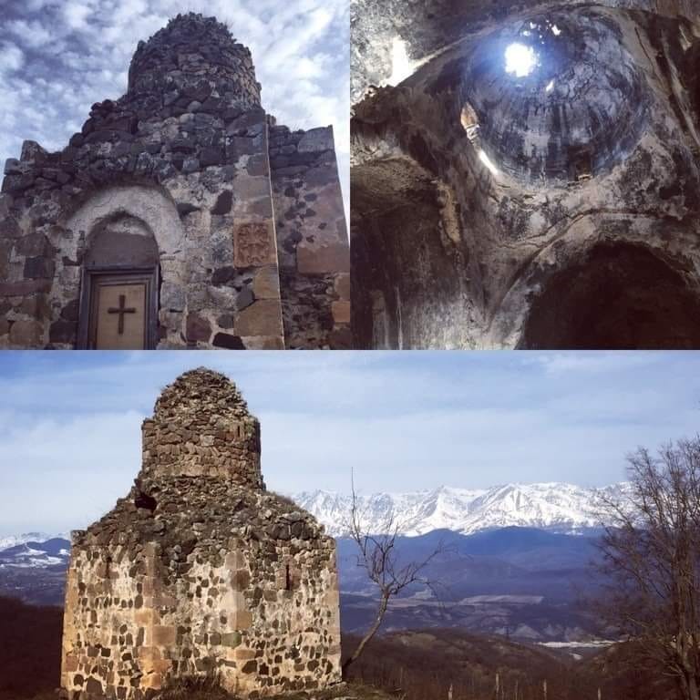
The Holy Saviour Monastery is located between the villages of Kochoghot, Chldran, Ghazarahogh, Poghosagomer, and Drmbon in the Martakert province, on the right bank of the Tartar River, in a picturesque mountain valley. Studies have shown that there was an older structure on the place of the church, and the evidence is the two-tiered pedestal, which is older than the building on the top of it. Although the exact date of the construction is not specified, the mentioning of Prince Hasan and his son Vakhtang indicate that the pedestal was built at the beginning of the 13th century.
In the surroundings of the church, there are ruins of auxiliary buildings, carefully carved tombstones and cross-stones of old and new graves.
Havaptuk Monastery or Ruzan’s fortress
Havaptuk monastery is located in the Martakert province, Artsakh, in Verin Khachen, 5 km south of Vank village. The monastery is named after the mountain on which it is located. The etymology of the mountain’s name is not known. The place is also known as Ruzan’s fortress. The monastery consists of large and small churches, a vestibule and other secular structures around them. In the eastern part of the monastery, on the slope of the hill, there are cemeteries.
According to the stone inscription on the facade of the southern altar of the church, the monastery was built in 1163 during the reign of Hasan's sons Vakhtang and Mamkhana. The monastery was built by Johan as a savior for himself and his beloved ones, as well as in memory of his parents. From the inscription it is also known why the monastery is called Ruzan’s fortress.
Hasan Jalal A had three daughters: Mamakhatun, Minakhatun and Ruzudan. The monastery was named after his daughter Ruzudan. Thanks to another inscription, we learn that the monastery was rebuilt in 1223 during the reign of Hasan Jalal Dola.
The inscriptions on the Havaptuk monastery and the surrounding cross-stones convey important information about the events and notable people in the region. There are also cross-stone tombs of one of the famous military leaders of Artsakh, prince Khaghbak B, 1194.
Khatravank or Khadar Monastery
The monastery complex is located 5-6 km west of Vaghuhas village of Martakert province, in a hard-to-reach place, it is considered one of the famous but not fully explored monastic complexes of Artsakh. This original and unique structure occupies a special place among the monastery complexes of Verin Khachen.
In various sources, the name is mentioned with different names: Khadavank, Khada Monastery, Khadi Monastery, Khadar Monastery. The root form of all these names is Khad, a personal name that belongs to Bishop Khad, one of the first Armenian clerics who was preaching in Syunik and Artsakh. Following the pronunciation features of the Artsakh dialect, the names Khadavank, Khadar monastery sound like Khatravank.
Under the western wall of the monastery’s main temple, there is a broken flat stone, on which ՌԿԴ (1215) is engraved, and an inscription says:
"I, Hasan and my mother Shushik built the St. Karapet in the same monastic complex…." In another inscription it is mentioned that in ՌԾԳ (1204) Ter Hovhannes built a church, collected crosses and other religious things, planted a young garden and donated it to the monastery.
It is known from the inscriptions on the monastery complex and other sources that Khatravank was one of the spiritual centers and burial places of the Vakhtang dynasty, Artsakh.
There is a valuable collection of cross-stones in the territory of the monastic complex, there are many old cross-stones also on the walls of Khatravank.
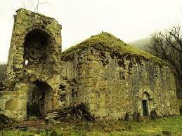
Hakobavank Monastery or Metsaranits Monastery
Hakobavank or, as it is mentioned in the history books, Metsaranits Monastery, is located 1.5 km from Kolatak village. Martakert province (Mets Arank province of historical Mets Hayk province, which was later renamed to Nerkin Khachen). The monastery’s name came from the relics of St. Hakob Mtsbnetsi. According to the oldest record, which was carved on the cross-stone dating back to 853. According to the chronicle sources, the separate buildings of the monastery, including the churches, were built, reconstructed and formalized from the 9th century to the 18th century. In one of the old manuscripts in Matenadaran it is said that the Metsaranits Monastery was rebuilt by Hasan-Jalali's mother, Princess Khorishah (XII century), sister of Ivane and Zakare Amirspasalars (supreme commander-in-chief ). In the Middle Ages, Hakobavank was a prominent pilgrimage place in Eastern Armenia, an important educational center and a place for the creation of manuscripts. In the 13th century, the monastery became residence of the Catholicos. The Metsaranits Monastic Complex consists of two churches and two courtyards.
Kachaghakaberd Fortress
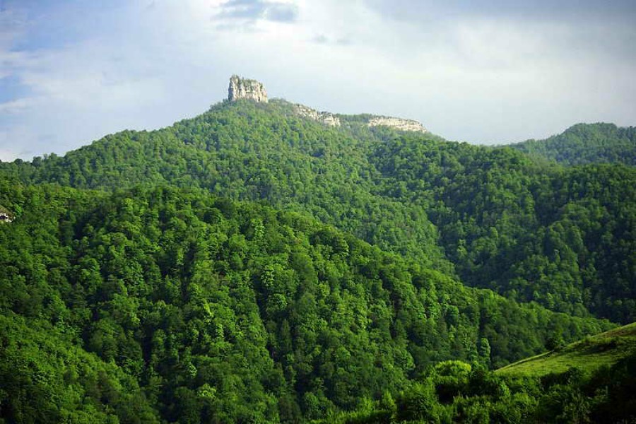
Kachaghakaberd or Khachen fortress is located near Kolatak village. This natural fortress was strengthened in the 8th century by the princes of Mets Arank province to save the population from the Arabic invaders.
According to Movses Kaghankatvatsi, in the 9th century a princess named Spram, having lost her husband, finds courage and, taking her surviving daughter with her, overcomes the long night path and finds a safe place in Khachen Castle."
Due to its location and inaccessibility, the fortress could be defended even without weapons. It is not a coincidence that people called the fortress Kachaghakaberd ( kachaghak- magpie), because only magpies could access it. The local residents know the place as "Sghsghan" (sghan - sliding) because there were many cases, when people slid back from the top of the mountain without reaching the wall of the fortress.
"Kichan Anapat" Monastic Complex
The monastc complex is located 1.5 km west of Kichan village. According to the preserved inscription, it is also known as "Khutavank". Locals also call it Napat: "Feast of Anahit". There's a spring called Anahit near the monastery.
The monastery consists of three churches, a refectory, a vestibule and groups of the congregants. There is also a large cemetery. Traces of the oldest inscription on the complex, which dates back to 1191, are still preserved on one of the cross-stones. It is not the only inscription, because more than 10 inscriptions have been found in different parts of the monastery.
The monastery is in a half-ruined state.
St Stepanos Monastery
St Stepanos Monastery is located in the north-western part of Tsmakahogh village.
In his inscriptions Hasan Jalalyan called this village on the left side of the Khachen River Tsmakahogh and also mentioned the relics of St. Stepanos and the church built in 1229.
According to archaeologists, the tomb of St. Stepanos was most likely built in the 5th-6th centuries, during reforms carried out by Vachagan III.
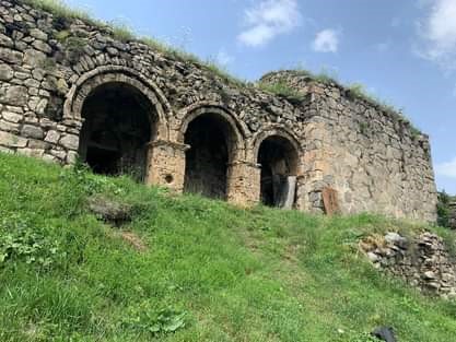
Kolatak "Koshik Anapat"
Koshik Anapat Monastic Complex is located in Martakert province, 7 km to the southwest of Kolatak village, in a forested area on a hill called Anapat. According to researchers, it was built in the 12th century. Locals more often call it simply Anapat. It consists of 3 churches, refectory, cemetery and cross-stones. The inscriptions are dated back to 1179, 1181, 1191, 1194, 1265.
The walls of the half-destroyed bathroom and clay water pipes have also been preserved in the complex.
Jraberd Fortress
Jraberd or Charaberd Fortress is located on the banks of Tartar (Trtu) river. It is an Armenian medieval structure. The medieval description of Jarberd came to us from Raffi's work "Khamsa's Melikdoms''.
The fortress of Jraberd’s Melik was located near the Tartar river bank, opposite to Yerits Mankants Monastery. The entire province is named after the fortress, because the fortress almost totally stands in the water, on the top of a huge wedge-shaped rock, scraping the foot of which pass furious rivers Tartar and Trghi.
The first owners of Jraberd Melikdom were the Melik-Israyelians. Then the castle was ruled by the princes of the Vakhtangian dynasty and their direct descendants. Prominent among them were Yesai Hasan-Jalalyan: the catholicos of Gandzasar, Malik Israelyan, Melik-Israelyan, Melik-Alaverdyan and prince Vani Atabekyan.
At the beginning of the 18th century, one of the powerful defense structures of Artsakh: Jraberd (Charaberd) fortress, was located here and later continued to be the main and important melik fortress of the province.
Only the ruins of the castle have been preserved to this day. The gates of the castle have been preserved.
Khokhanaberd Fortres
Khokhanaberd, Khavakhan, Khoyakhan, is located 4 km southwest of Vank village. Directly in front of it is Gandzasar, and to the south rises the wooded Tarkhanasar, the top of which was built and turned into an inaccessible fortress by Hasan-Jalal in the 13th century, it was the main fortress of Hasan-Jalalians. During the Mongol invasions and raids, most of the population of the province took shelter and protection there. It was finally destroyed in the XV-XVI centuries during the Turkish invasions. Remains of walls and buildings are preserved.
According to one tradition, the name is etymologically explained as follows. They bring news to Jalal Dolu that "your wife has given birth to your child". The prince named the fortress Khokhanaberd in honor of the child.
- Բացվել է 442 անգամ
